The Bolton Street Cemetery Heritage Area has its origins in the reservation of land for public cemeteries provided for in the planning at the founding of Wellington as a colonial city in 1840. The New Zealand Companyset aside 7.3 hectares of land for what would become the Bolton Street Cemetery. This common cemetery was part of the Company’s plan of creating a more egalitarian society, in that it was intended to prevent graveyards gathering around churches and thereby helping to reduce the sectarian divisions that surrounded burials in England.
Bolton Street was set aside for the use of all citizens regardless of religious belief, with the exception of Catholics who in any case had their own cemetery at Mount Street. The cemetery’s status was duly confirmed when Governor Hobson visited Wellington in August 1841. The dead immediately began to be interred there, after they had initially been buried at Petone and then on Wadestown Hill.
Despite its egalitarian aspirations, the cemetery ran almost immediately into sectarian issues. Although the land had been divided into three general categories – Church of England, the Jewish community, and general public cemetery – burials were taking place in an unregimented way, much to the unhappiness of the Church of England and the Jewish community, who were used to burying their deceased in separate and consecrated ground. Non-conformist churches, such as Methodists and Presbyterians, closely monitored developments at the cemetery to ensure no church gained an advantage in burials.
In 1842, in an act of protest against what was seen as the improper administration of the cemetery and segregation of burials, the Church of England, led by Bishop George Selwyn, fenced off what had been designated as its section of the land.This meant that visitors to burials within its land (for example, non-conformist churches’ burials) would have to apply for permission to visit the graves, and when a family member (in particular a spouse or child) died, they would have to be buried elsewhere. This act caused a great deal of resentment and it was some time before the dispute was resolved. The solution reached by the Church of England with the non-conformist churches was that the church had to be furnished with a list of those who wished to be buried in the disputed ground, and that they could be buried there by their own ministers only by special permission, not by right.
By 1849, these demarcation disputes were beginning to be settled and the land was finally divided into agreed sections. Two were set aside for the Church of England, two for a general public cemetery, and one small section for the Jewish community. A Crown Grant for the Church of England cemetery was issued on 25 March 1851 for a total of just over 2.8 hectares. That for the Jews was issued on 9 November 1852 for a total of 0.3 hectares. By an act of management assented to in the Wellington Provincial Council in January 1854, the public cemetery received a total of over 3.2 hectares. Its Crown Grant, however, was not issued until 24 January 1860.The first maps of the cemetery were drawn by New Zealand Company surveyors, with Thomas Fitzgerald annotating the S.C. Brees’ map of 1844 to show where the agreed-upon internal boundaries fell.
With the reserve, for all intents and purposes, divided into three cemeteries, eventually each cemetery had its own trustees, and the two largest had their own sexton. Management of the cemeteries was carried out by the trustees, and income came mainly from burial fees and the lease of plots. However, until the population of the town increased, the deaths were too few to provide realistic incomes for the maintenance of the cemetery, and there was constant criticism of both the cemetery’s appearance and its difficult access.The trustees were well organised and in 1857 the trustees of the two large cemeteries arranged for cottages to be built for their sextons to reside in on-site.
Sextons
Until the 1850s the grave digging and caretaking of the cemetery had been carried out by Harry Bridger Buxton, a gardener who had arrived in 1840 and died in 1847, and then by James Futter, who was also verger for 25 years at St Paul’s and St Peter’s churches. Futter likely confined his work to the Church grounds from that date until his retirement in 1865.
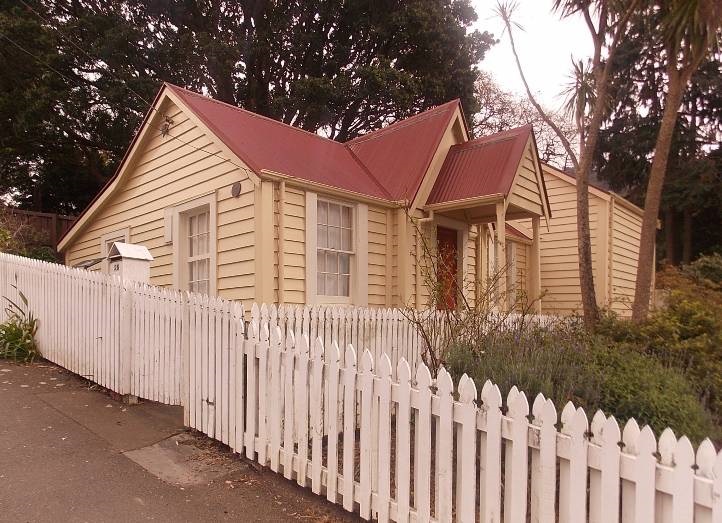
The Church of England Sexton’s Cottage was built in 1858 (see 3.2).
Public Cemetery
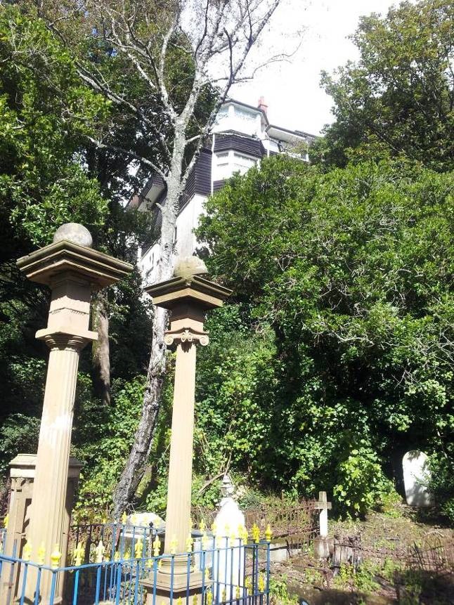
In 1857 gardener David Robertson was appointed sexton for the public cemetery. Robertson had come to New Zealand with years of horticultural experience from estates in England, and his contribution to the cemetery can still be seen in the orderly layout and management of the public portion of the cemetery, in particular the well placed paths and brick channels. He shared an interest in native flora with Sir George Grey, and feared that many would become extinct, so made a point of collecting a number of species and propagating them in the cemetery so that they would be preserved.
The sexton’s cottage for the public cemetery was situated on the sunny ridge to the east of the Jewish cemetery boundary, with a fine view over the harbour and towards the mountains and Hutt Valley. It was constructed in timber, with a shingle roof, and had four rooms with the front door opening onto the parlour. Along with the cottage Robertson was granted an area to cultivate, and he kept a cow.
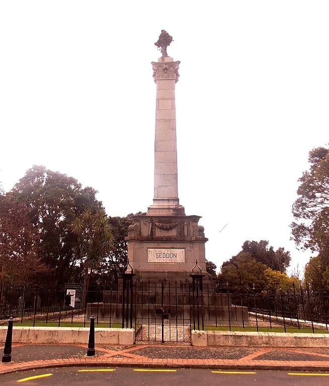
The cottage had narrowly escaped being pulled down in 1906 when the site was considered for the burial place of Premier Richard Seddon, as Mrs. Robertson was poorly at the time (dying soon after) and humane considerations demanded that she be left in peace. The cottage remained the home of the Robertsons until it was demolished in 1908.
Over its history the cemetery had various names. The Church of England portion was known as the Bolton Street Cemetery, while the public portion was known as the Sydney Street Cemetery. Following 1892 the whole area was known as the Town Cemetery, and after 1940, it became known as the Bolton Street Cemetery.
Closure of the Cemetery and land losses
Although in the beginning the cemetery was well away from the first areas of settlement in Thorndon and Te Aro, by the 1880s it was surrounded by residential development. Inhabitants of the area raised concerns about having a cemetery in what had become a densely populated area of the city, making the cemetery a scapegoat for their fear of disease and epidemics.
As early as the 1860s the siting of the cemetery had been recognised as a mistake, and Dr William Fitzherbert, Superintendent of Wellington Province from 1871-75, acknowledged that ‘to continue much longer the use, for purposes of interment, of a piece of ground sloping towards the centre of a town whose population is steadily increasing will be highly injurious to the health of the inhabitants’.
Debates ensued between the government and council as to whose responsibility it was to find a site for a new cemetery, the testing of the new site, and the preparation and carrying through of legislation that would provide for the new cemetery. The discussions went on for years, and some progress was made towards the closure of the cemetery with the passing of the Cemeteries Act of 1882, but the law required that a new site be found before the existing one could be closed. Eventually, in 1889, 38.5 hectares at Karori were purchased for £4,000 from the McKenzie family of Rosehaugh, subject to the formation of Raroa Road to connect this area with the southern end of the city. The preparatory work proceeded apace and Karori Cemetery received its first burial in August 1891.
The location of Bolton Street Cemetery had not been the only consideration that was taken into account when it was decided to close it. Several other issues had been at hand, with one of the most pressing being the fact that Thorndon, despite being a popular and quite affluent suburb, had no recreation grounds, meaning that those who wanted to play organised sports had to travel to the Basin Reserve or Newtown Park.Councillors Dr A.K. Newman, and George Anderson, were champions of the campaign to establish a park at Thorndon.
In 1888 the City Engineer estimated that two hectares from the hill and gully at the head of Sydney Street could be developed for a park at a cost of £4,500. Although the land was part of the cemetery’s reserve, it was leased to the Botanic Garden Board and had been planted with pine trees. The opportunity for acquiring this land for the purpose of a park space was nearly lost in 1890 when the public cemetery trustees became desperate for more burial space and opened some of their reserve on Glenbervie Hill near Tinakori Road for burials (despite the notice that was served in the 1882 Act). Both the public trustees and the Church of England trustees had been warned that their existing burial grounds were fast approaching capacity, but neither group had done anything to remedy the situation, so burying in the reserve areas became the only option. The burials in the church reserve did not affect the planning of the park space, but the public burials did, and by the time the final closing order for the cemetery came in 1891, 55 interments had been made on Glenbervie Hill.
It was not until 1906 that a loan was raised for the development of the park (the cost since 1888 having doubled in that time due to inflation), and as a result the Glenbervie Hill burials were transferred to a portion of the former church reserve ground which, after the closing order, had been placed under the control of the Wellington City Council (WCC). Spoil for Anderson Park (as it was later known) came from several sites, first from workmen preparing the site for the Seddon family vault, and then from Glenbervie Hill, originally some 25 metres high and reduced by means of hoppers, trucks, tramway and steam digger.
The park was not the only encroachment into the cemetery carried out in the late 19th and early 20th century. Residents of Karori and the western suburbs had long been petitioning for better access to their homes from the city and pressed for a road linking Sydney Street with Tinakori Road. Work began in 1885 on a road that ran parallel to Sydney Street from the public cemetery entrance and gave access to the southern end of Tinakori Road. Land was taken from all three cemeteries for the project, with the Jewish cemetery losing nearly half of its land, but as the affected land was steep and unsuitable for burials, no objections were raised and the compensation offered by the WCC was taken. The new road, called Glenbervie Road, was ready for use in 1886.
In 1906, two years after the introduction of the electric tram to Wellington, proposals were raised to re-grade Glenbervie Road to replace the existing tram route to Karori that ran along Molesworth Street. The matter was debated for some years and more than 17 routes were examined. Finally in 1928 after considerable public pressure an earlier decision to take the road through the cemetery with disturbance to graves was rejected in favour of demolishing 12 houses on W.B.D. Mantell’s subdivided property on the boundary of Sydney Street. Work began in 1929 but was halted for some time. Finally, Bowen Street, which until then had ended at Mowbray Street, was continued around the edge of the cemetery to link up with a much lower Glenbervie Road, before joining into Glenmore Street. When completed in 1940 the entire stretch was renamed Bowen Street.
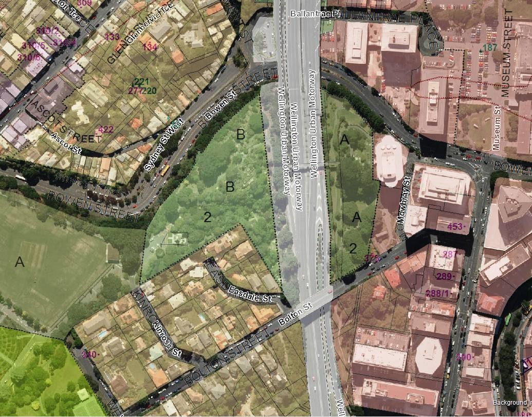
The Wellington Urban Motorway and Bolton Street Memorial Park
Outcry against the desecration of graves saved the cemetery from a roading intrusion in 1928, but it was not to be the same story 35 years later. In the early 1960s, the Ministry of Works, acting for the National Roads Board and with the agreement of the WCC, proposed a likely route for a new urban motorway through the middle of the cemetery. The public response to the proposal was led by the Bolton Street Cemetery Preservation Society, chaired by zoologist Professor John Salmon. The society voiced the concerns of many over the destruction of a historic place and the further loss of valuable green space in the city.
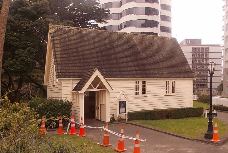
However, despite years of protests, the act authorising the taking of land for the motorway was passed in 1967. It involved driving the road through 1.5 hectares in the middle of the cemetery, an area that included some of the oldest burials as well as the mortuary chapel. Although protests could in the end do little to prevent the entry of the motorway into the cemetery, they did encourage the Ministry of Works and Development to take great care over the design of the area. The proposed plans were made public in 1965, and originally featured a wide, lightly planted piazza across the motorway linking the severed pieces of the cemetery, a crypt recording the names of those disinterred, as well as extra open space on the Mowbray side of the cemetery (which was at the time occupied by the University Grants Committee Building) through a land swap with the University. None of this eventuated.
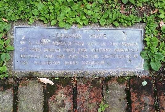
Public access to the cemetery ended in November 1968. Preparatory work began on the motorway, beginning with liaison with the families of those whose graves were affected. The demanding task of disinterring the remains and transferring them to a common grave was carried out by the city sexton P.J.E. Shotter. Almost 900 memorials were removed to storage, first on Sydney Street and then to Karori Cemetery, where they remained for eight years until they were reinstated in the remnants of the Bolton Street Cemetery. In 1974 a group of volunteers copied all of the inscriptions from these memorials and these were then used in 1977 by the Friends of the Bolton Street Cemetery to demonstrate to the Ministry of Works that, such was the importance of these memorials that they needed to be reinstated appropriately rather than arbitrarily. The memorials were reinstalled by crane on the stretches of back fill behind the motorway walls, and in groups wherever space could be found for them.
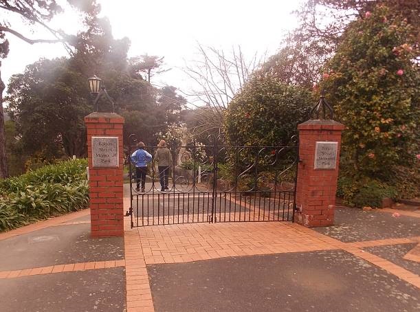
The section of motorway running through the Bolton Street cemetery opened on 21 May 1978. Ian Galloway, the Director of Parks and Gardens, then arranged for the cemetery to be administered as a historic reserve by WCC under the Reserves Act 1977, and a management plan was produced to ensure that the remnants of the cemetery including the graves and memorials were professionally maintained.The WCC Parks Department approved the new name of Bolton Street Memorial Park for the cemetery and motorway-related features and structures.
The Friends of the Bolton Street Cemetery was formed in 1977 to safeguard the remnants of the cemetery. One of the Friends’ first efforts was making sure that the matter of additional land along Mowbray Street was not forgotten. The promise of this land had been a key element of the public acceptance of the motorway. The land that was promised only represented a fifth of the cemetery land that was taken by the Road Board (for free), and the piazza that had been part of the original plans was replaced with two footbridges (only one of which was actually in the cemetery) at a great saving of money.
For 12 years, with the support of several other societies and a lawyer on the committee, the Friends kept up a relentless correspondence to all of the institutions involved including the Mayor, councillors and staff of the WCC, the National Roads Board, Ministers of the Crown, members of Parliament, and the Dairy and Meat Producers Board, to ensure that their obligations to the public were met. Eventually the National Roads Board paid the WCC $500,000 for the land, with a further $50,000 for the rebuilding of the mortuary chapel (see also 3.2).
It was decided that the Mowbray Street area had good potential as parkland, but the available money was not enough to acquire the land. To add to the difficulty, the WCC had re-zoned the land in preceding years, marking it for office rather than residential development. To find a solution to meeting their obligations, the Council approached Fletchers Development and Construction Limited to work out an agreement with adjacent property owners for the development of the land. The plans were released in 1986 and provided for a high rise building on the site of the former University Grants Building, coupled with a largely subterranean car park that would be landscaped over the top to act as a link to the cemetery boundary; this land would incorporate the Sexton’s Cottage, the reconstructed Mortuary Chapel, and a memorial for those who had been disinterred for the motorway. The development, a visual extension of the cemetery, was opened in March 1990.
In 2002, Morva Williams, the first wife of economist Bill Sutch, who had lived at 2 Easdale Street for 60 years, bequeathed a part of her property to the park upon her death.
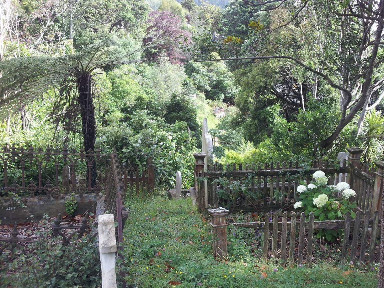
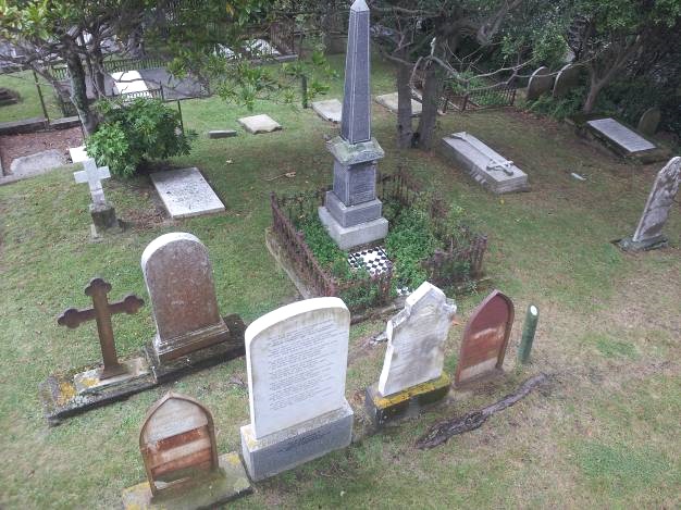
Physically, the area has not changed a great deal since then. The appearance of the cemetery has been significantly upgraded over time, including the restoration of graves and memorials and the provision of interpretation and way finding. The Friends of Bolton Street Memorial Park remains a key force in influencing the direction and priorities of the park’s management.